
LiDAR
Cybermap
Sensors fused. Spaces digitized.
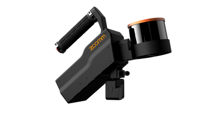
A handheld LiDAR platform whose fusion algorithm combines point cloud, vision, SLAM, deep neural networks and machine learning — handheld, vehicle-mounted, airborne or backpack.
 1 / 3


Fusion, not just scanning.
3D point cloud, vision, SLAM, deep neural networks and machine learning from multiple sensors, integrated into one algorithm — high-resolution, true-to-life models with point clouds converted automatically into real spatial coordinates.
Handheld today. Airborne tomorrow.
The quick, adaptable design moves between handheld, vehicle-mounted, airborne and backpack modes — the same scanner from a mine tunnel to a factory floor.
Underground, no GPS required.
Rapid, accurate 3D modeling of mine tunnels without GPS positioning — boundary monitoring, spatial distribution, fire safety and seepage detection from one capture.
In detail.
An integrated fusion algorithm that combines 3D point cloud, vision, SLAM, deep neural networks, and machine learning from multiple sources of sensors. In addition to handheld use, vehicle-mounted, airborne, and backpack mode are also provided by Cybermap's quick and adaptable design. Widely applied in real-time 3D modeling, VR/AR, BIM, underground mining, and many other areas, enabling rapid digitization of three-dimensional physical spaces.
Mine Tunnel
Without GPS positioning & navigation, Cybermap can rapidly and accurately scan underground spaces to complete 3D modeling. It covers aspects including boundary mining monitoring, spatial distribution analysis, fire safety monitoring, water seepage detection and pest infestation. It can achieve high-precision measurement and monitor 3D spatial information inside mine tunnels, help to enhance mine safety and contribute to digital mining development.
BIM
Cybermap's SLAM technology enables rapid and accurate modeling and mapping of various scenes, whether indoor, outdoor, or in narrow and small spaces. This encompasses aspects such as 3D modeling, digital twin technology, reverse modeling, and geographic environmental inspections. It efficiently captures three-dimensional point cloud data of buildings, infrastructure, and other objects, enabling precise modeling and simulation.
Industrial Applications
Cybermap can quickly model data with high resolution and accuracy, providing true-to-life information. Point clouds can also be automatically converted into real spatial coordinates. This encompasses aspects such as digital factory construction, digital twin technology, structural change analysis, and spatial management.
VFX (Visual Effects)
Cybermap's efficient real-time data capture is highly suitable for applications in the VFX field, including film and television, VR/AR, and the metaverse. This covers aspects such as AR/VR experiences, 3D modeling, acquiring real-world scene data, and spatial management.
Applications
- Real-time 3D Modeling
- VR/AR
- BIM
- Underground Mining
- Digital Twins
- VFX
See it in action.
Tech Specs
- Technology
- SLAM fused with 3D point cloud, vision and machine learning
- Positioning
- Operates in GPS-denied environments (indoor, underground)
- Mounting
- Handheld, vehicle-mounted, airborne or backpack
- Outputs
- Real-time 3D modelling; point clouds in real spatial coordinates
Keep exploring.


See the Cybermap on your own site.
The fastest way to judge it is in your own field conditions. Book a demo and our team will bring it to you — or ask about rentals.